1. Introduction
1.1. Motivation
Coastal zones are highly dynamic environments that evolve continuously over time and space due to the influence of of atmospheric, oceanic, and terrestrial processes. Given this complexity, coastal engineering studies and projects must integrate diverse approaches to comprehensively analyze and address the challenges associated with coastal morphodynamics. The use of customizable tools and models is essential for understanding these processes and, where feasible, mitigating their impacts to preserve the natural environmental balance.
Coastal morphodynamic models are typically classified based on several criteria, including their nature, level of accuracy, temporal and spatial scales, as well as the variables incorporated into the formulations. For example, coastal models may be grouped into three categories of temporal scales:
Short-term models: Covering hours to days, these are often used for analyzing immediate or transient coastal processes.
Medium-term models: Spanning days to years, they are suited for studying seasonal or interannual changes.
Long-term models: Addressing years to decades, these are applied to evaluate gradual trends and large-scale coastal evolution.
Very long-term models: Ranging decades to centuries, these are relevant for studying climate change and evaluating its potential effects.
Following the same logic, spatial scales may be categorized as:
Micro-scale models: Covering millimeters or centimeters (ripples) to tens of meters (cusps), they focus on localized phenomena.
Meso-scale models: Spanning hundreds of meters, these are suitable for intermediate areas like bays or small coastal zones.
Macro-scale models: Extending to kilometers, they are designed for analyzing regional coastal systems.
Despite significant advancements in coastal modeling over recent decades, no single model is capable of simultaneously analyzing and predicting coastal evolution processes across a wide range of spatial and temporal scales. Instead, the inherent complexity of coastal systems often requires the application of multiple models, each tailored to a specific aspect or process of the problem. By combining the strengths of multiple models, it becomes possible to address the full range of objectives, ensuring a more comprehensive understanding and effective analysis of coastal dynamics evolution.
For diagnostic or preliminary studies, coastal engineers often rely on simplified tools, such as empirical formulations to estimate static and dynamic equilibrium conditions or heuristic models to assess coastline position changes. These tools are highly effective for quickly inferring morphodynamic processes and providing initial insights. In contrast, more detailed studies require robust models capable of integrating multiple variables and processes to deliver realistic projections of future coastal morphology. However, it is important to consider that as the complexity of simulations increases by incorporating more variables and processes, the computational cost also rises significantly. This often limits the feasibility of conducting realistic simulations over larger spatial and temporal scales.
In recent years, the Coastal Engineering and Management (CEM) Group at IHCantabria has developed a suite of models adapted to address varying scales and complexities of coastal studies. These tools range from simplified models based on empirical static equilibrium formulations, designed for rapid environmental diagnostics, to more sophisticated models grounded in dynamic processes for comprehensive investigations of coastal morphodynamics. However, these models were developed independently, without an integrated framework to facilitate intuitive communication among them. Despite their complementary nature and the often close relationship among their outputs, the lack of interoperability has posed challenges in their real potential for coastal analysis.
The IH-SET (IH-Shoreline Evolution Tools) project was established to address the need for integrating the key coastal dynamics models developed by the CEM Group, as well as those frequently cited in literature, into a unified platform. This integration streamlines the application of these tools, enhancing their accessibility and usability for coastal engineering and management projects. By providing an intuitive interface, IH-SET makes coastal modeling tools more user-friendly and appealing for professionals from varied backgrounds. The platform enables users to select and compare methodologies ensuring a customized and efficient modeling experience.
Moreover, as an open-source initiative, IH-SET fosters collaboration between users and the CEM team of experts. This collaborative framework supports the development of a network of coastal engineering scientists specializing in beach morphodynamics, with the shared goal of continuously advancing coastal modeling tools.
1.2. Outline
The primary objective of IH-SET is to integrate the static, dynamic, and evolutionary approaches to morphodynamic modeling into a singular tool, facilitating the efficient prediction of coastal evolution on multiple temporal and spatial scales. IH-SET provides concise technical descriptions of the incorporated models, seamlessly integrating them into its platform. This modular approach enables coastal engineers and managers to perform morphodynamic analyses across various spatial and temporal scales, whether for targeted project applications or for assessing a beach as a physiographic unit.
A schematic infographic illustrating the general structure of IH-SET is provided in Figure 1-1.
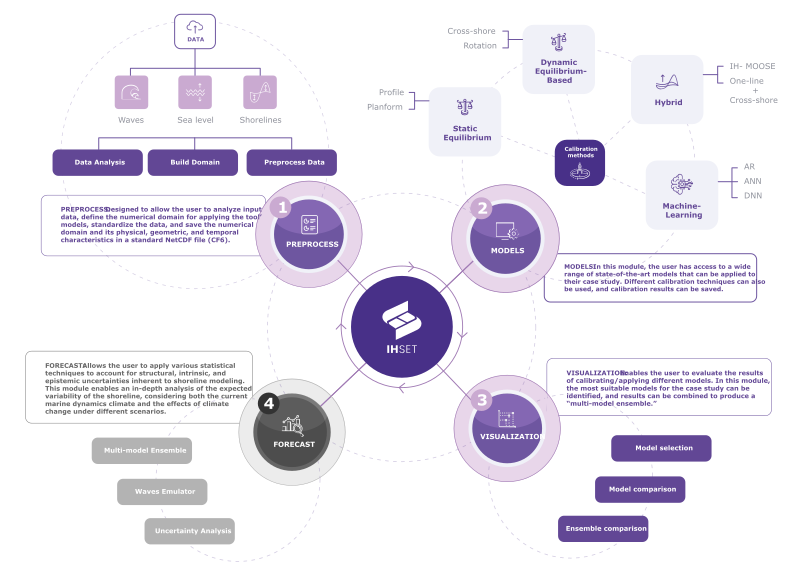
Fig. 1-1. The general structure of the IH-SET tools.
To provide a unified and comprehensive understanding, each model within the IH-SET platform is accompanied by concise metadata descriptions. These descriptions ensure clarity regarding the model’s scope, functionality, and applicability. Figure 1-2 presents a preliminary list of models currently included in the IH-SET platform as well as those planned for future integration. The initial release of the tool will feature the models highlighted in green, which represent methodologies developed by the Coastal Engineering and Management Group at IHCantabria.
For detailed information on the functionality and implementation of these models, please refer to the Modules section.
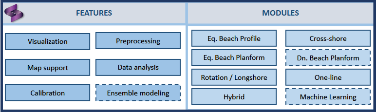
Fig. 1-2. Selected features and modules included in IH-SET and planned for future versions.